 The Tagis Mobile App
Tagis Mobile serves as your all-in-one access point to the Tagisphere, connecting you to a world of AR content and geotags for all project types.
Click Here to download Tagis Mobile from the Apple App Store to your iOS device
Secure Login or Public Access
When you create and populate projects with geolocated AR content (geotags), you control if the content is public or private. You can invite your frontline team members, partners, and customers to create a Tagisphere account and have secure access to your project data with the FREE Tagis Mobile app.
Feature Details:
Mobile App: Tagis Mobile
DESCRIPTION: Tagis Mobile is a FREE app that can be found in the Apple App Store or Google Play.
SECURITY: Public Access
DESCRIPTION: Projects set as "Public" allow any user with the Tagis Mobile app find and explore your Tagisphere AR geotags. The users can launch the app in an anonymous mode and will be able to see any project and project data that you have set to be public.
SECURITY: Restricted Access
DESCRIPTION:
Setting the security mode to "Private" protects your data from any unauthorized users. In fact, without an authorized login account, no user will even be aware there is any project or data near them at all. It is easy for your project administrator to set up authorized user accounts by simply inviting users via their email address to join the project, via their email address, from the Tagisphere Admin Portal.
VIEW MODE: AR
DESCRIPTION:
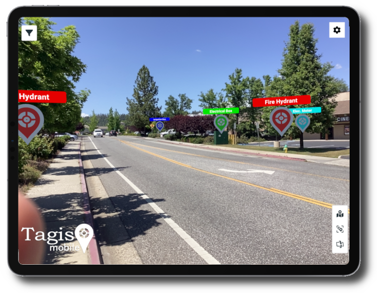
The Augmented Reality (AR) view mode uses a full screen camera view and displays geotag icons placed at the assigned geolocations in the scene. The geotag icons have a label and most often also are also hyperlinked. The view mode can be easily selected/toggeled by the view mode icons at the bottom right of the screen view.
VIEW MODE: Map
DESCRIPTION:
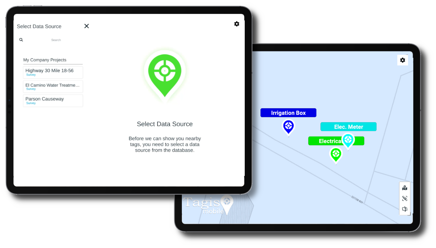
The Map view mode displays a map of the users current location which displays geotag icons placed on the map. The geotags have a label and are most often also hyperlinked. The view mode can be easily selected/toggeled by the view mode icons at the bottom right of the map view.
VIEW MODE: Auto-Tilt
DESCRIPTION:
When activated, the Auto-Tilt mode monitors the orientation of the mobile device. When it senses that the device has been "laid down" flat (camera looking towards the ground) it auto-toggles the View Mode into Map view mode. When the device is oriented with the camera not facing the ground, Auto-Tilt mode toggles the app into AR view mode. See the system settings section for more information on controlling Auto-Tilt features.
FILTER: Data Source
DESCRIPTION:
Upon launching the Tagis Mobile app and logging in, the user is presented with a list of available projects. They must select a project to proceed. Users will only see a list of nearby projects. Only projects with tags close enough to see will be available for selection. If the user users a Public login, they will only see nearby Public projects. If the user has credentials to log into an organization, then they will see any projects where they are an included member.
FILTER: Category / Subcategory
DESCRIPTION:
Geotags may (optionally) be orgnized in categories and subcategories. Once a user has selected a project data source, they will have a list of Categories and Subcategories as provided with that project. They can use these filters to turn on/off seleted sets of tags.
POSITIONING: Basic GPS
DESCRIPTION:
Tagis Mobile utilizes several positioning technologies. The positioning capabilities allow the app to understand where the user is standing in the world and where the device is looking. By default the system uses the built-in GPS capabilities of the mobile device. Built-in GPS provides a rather low level accuracy, however the app will work within the limits of accuracy provided by the built-in GPS.
Click Here to learn more about all of Tagis Moblle positioning technologies including GPS and VPS.
Click Here to learn more about all of Tagis Moblle positioning technologies including GPS and VPS.
POSITIONING: Enhanced GPS/GNSS
DESCRIPTION:
App users can utilize an external GPS/GNSS antenna to enhance/improve the positional accuracy of the device. Low cost antenna units from Bad Elf and Arrow can provide accuracies down to a meter fairly reliably. Commercial grade units from companies like Leica and Trimble can provide positional accuracies at the centimeter level. In most cases the user configures the antenna to communicate with the mobile device as instructed by the antenna manufacturer. Then the Tagis Mobile app can access this improved positional accuracy in an automatic fashion when the external antenna is configured to replace/augment the built-in GPS capabilities. The device provides "Location Services" to Tagis Mobile and the enhanced antenna systems improve the mobile devices location services automaticially.
POSITIONING: Azimuth/Compass
DESCRIPTION:
GPS/GNSS systems can both provide very accurate positional accuracy. They can locate the precise location of the device on the globe. However, they do exhibit some inherent limitations in azimuth or compass accuracy, potentially varying by several degrees. This causes AR content placement location to become less and less acurate the farther away it is from the device. 1 degree of error can produce a location off by several feet at 100 feet away from the device location and a few degrees of error compounds that error of course. Tagis Mobile provides some easy to use features that alolw the user to provide manual corrections for the azimuth/compass direction. Once a correction is provided, the system esentially "locks in" the correction and it remains valid until the user has traveled a significant distance from the location where they provided it. This is called drift and the system provides feedback when it detects/assumes drift has occured.
POSITIONING: VPS
DESCRIPTION:
VPS (Virtual Positioning System) deployments utilizes computer vison technology to determine the user position as opposed to GPS/GNSS. VPS may be used in addition to GPS/GNSS and it is implemented automaticially. The user may be completly unaware and does not need to turn it on or off. If VPS is available at the user's current location, Tagis Mobile automaticially uses it for positioning. VPS uses an exemplar model of the scene called a spatial map. Therefore, it requires some reality capture process to capture a spatial map of the scene/location ahead of time to be able to work. Again, the Tagis Mobile app users are typially not even aware this has been done and have nothing they need to do. VPS computer vision uses the device camera to look at the cuurent location and match what it sees to the spatial map (exemplar model) of the location to determine the exact position and orientation of the mobile device in the scene. This is a continual process and happens automaticially in the background. The VPS system may use GPS/GNSS to get a nominal position and then be able to determone which spatial map location to begin utilizing.
POSITIONING: Public VPS
DESCRIPTION:
Public VPS utilizes the Google Geospatial API technology to position the user/device in the scene. Google's geospatial capabilities provide public spatial maps for a large portion of urban spaces all over the globe. These spatial maps are derived from Google Street View imagery and cover more than 10,000,000 miles of roadways in more than 87 countires around the globe.
POSITIONING: Private VPS
DESCRIPTION:
Private VPS utilizes custom spatial maps. These maps must be created by the user's organization using a reality capture process.One key advantage of private VPS is the ability to work flawlessly indoors, so you can utilize the Tagisphere in a factory, plant, warehouse, office, labratory or esentially any desired facility. Private VPS is not restricted to indoor use either and can be utilized in most situations. Many organizations can easily create their own spatial maps, given guidance by AR Mavericks. Mavericks also has a global network of service providers who can be contracted to perform this quick service. Mavericks can also instruct you preferred local reality capture service how to perfomr the required spatial map creatin process.


