Tagis CAD Civil 3D Add-on
 This FREE CAD plug-in for AutoCAD Civil 3D allows you to place geotag blocks in any geolocated drawing. You can then immediately publish them to the Tagisphere, creating hyperlinked geotags anywhere on the globe.
Click Here to download the Civil 3D plugin from the Autodesk App Store
Instantly Publish Tags from your Desktop
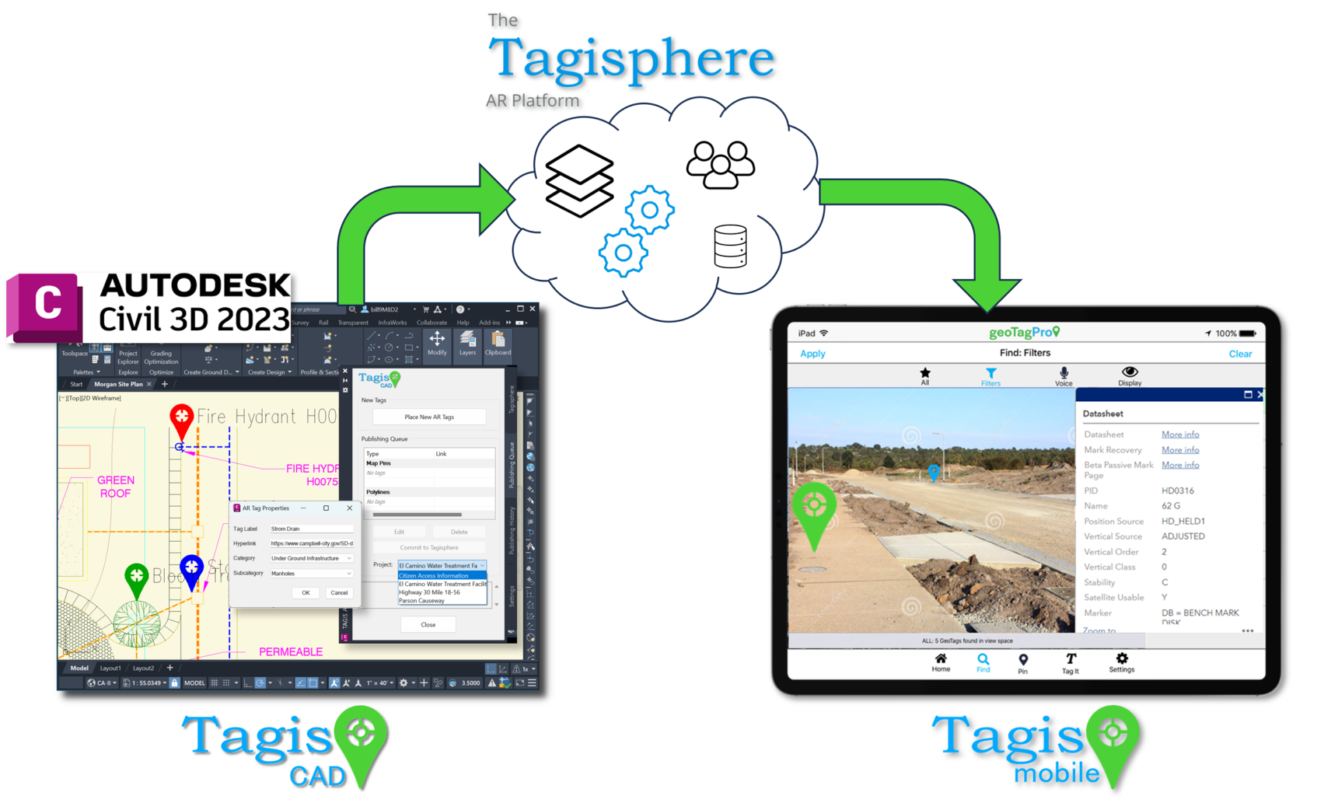
Tagis CAD lets you publish AR geotags from a Civil 3D desktop session. Your tags are stored in the cloud-based Tagisphere AR Portal and become instantly available to your Tagis Mobile users in the field. Users have a secure connection to the cloud service, with user and project authorizations controlling publishing permissions.
Feature Details:
ADD-IN App: Tagis CAD
DESCRIPTION: Tagis CAD is a FREE Civil 3D add-in app. After installation, the app's launch icon appears in the Add-In tab of the Civil3D menu ribbon.
Users can place geotags (customized blocks) in their current drawing and 'Publish' them to the Tagisphere AR Platform. In the Tagisphere, geotags appear as geolocated augmented reality (AR) pins visible in real-world environments, containing labels and hyperlinks to access cloud-based data or applications.
Users can place geotags (customized blocks) in their current drawing and 'Publish' them to the Tagisphere AR Platform. In the Tagisphere, geotags appear as geolocated augmented reality (AR) pins visible in real-world environments, containing labels and hyperlinks to access cloud-based data or applications.
SECURITY: Login Credentials
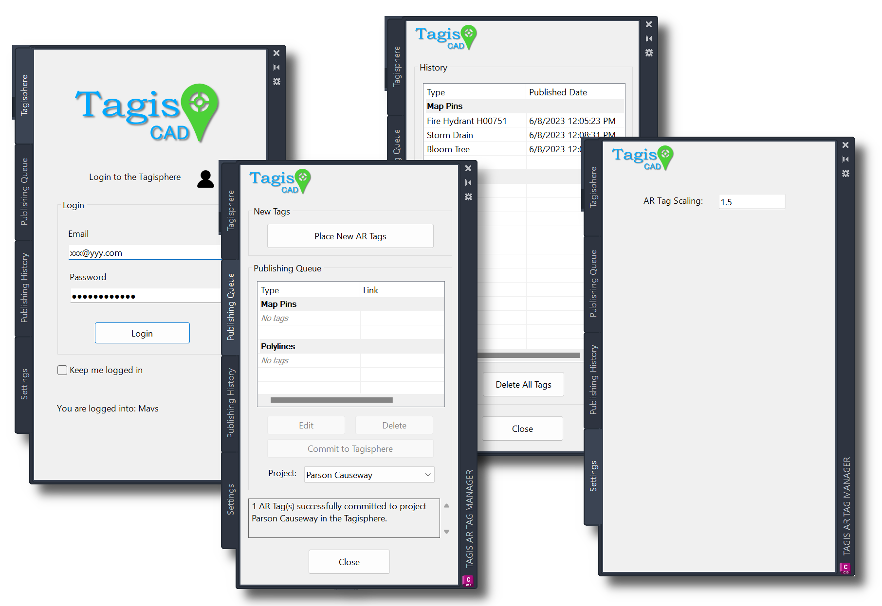
DESCRIPTION: Upon launching the Tagis CAD add-in app, users are prompted to enter their organizational credentials. Users create their own Tagisphere credentials after accepting an invitation to join their organization’s Tagisphere community. These invitations are sent by the company's Tagisphere Administrator. With these credentials, users can log in to the Tagisphere and access all projects they are members of.
CONNECTED: Cloud-Based Backend
DESCRIPTION:
The Tagisphere AR Platform offers a cloud-based backend where the organization's Tagisphere Administrator manages all project data. This backend provides storage and connectivity for publishing AR content and for mobile app users (field workers) to access AR geotags in the real world. Once logged into Tagis CAD within their Civil3D desktop session, users are automatically connected to the backend. To publish geotags, users first place them in the drawing at the desired location. After placing one or more geotags, the user then issues a "commit" command to publish them to the Tagisphere, making AR geotags instantly available at their real-world locations.
DATA ORGANIZATION: Projects
DESCRIPTION:
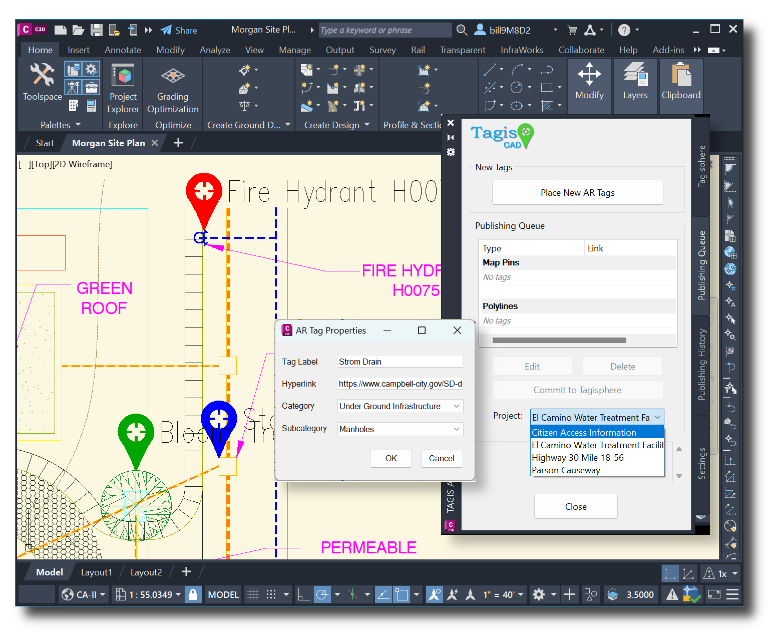
The primary organizational unit for Tagisphere data is the Project. Projects are created in the Tagisphere AR portal. Users can be invited to join multiple projects within their organization. Users log in to their Tagisphere organization from within a Civil 3D session. They then select from a list of projects they belong to and can begin placing geotags.
DATA ORGANIZATION: Categories
DESCRIPTION:
Each geotag can include Category and Subcategory attributes. Field users utilize the Tagis Mobile app to locate and access geotags. They can use the Category and Subcategory attributes to filter local AR geotags. This feature enables users to more easily find geotags of interest.
Categories and Subcategories are optional attributes so users can create geotags without any category or subcategory if they wish. Categories and subcategories are defined by the Project Administrator using the Tagisphere AR portal. Tagis CAD users cannot create new categories or subcategories, they are shown a list of available choices as part of the geotag placement process.
Categories and Subcategories are optional attributes so users can create geotags without any category or subcategory if they wish. Categories and subcategories are defined by the Project Administrator using the Tagisphere AR portal. Tagis CAD users cannot create new categories or subcategories, they are shown a list of available choices as part of the geotag placement process.
DATA VALUES: Location
DESCRIPTION:
The basic concept of the Tagisphere is to provide geolocated tags (geotags) at specific locations on the globe. To support that capability, geotags published from Civil 3D must be placed in a drawing that has a defined geolocation. Users can set any global available geolocation geolocation zone or coordinate system. The Tagisphere back-end translates and stores all values in Lat/Long but users may work in any global coordinate system they prefer.
Users don't need to do anything special other than making sure a global geolocated coordinate system has been selected and set using Civil 3D's built in geolocation tools. Then users simply place the geotag blocks at any desired location in their drawing, using the Tagis CAD Add-in app and when committed to the Tagisphere, the geotags will be placed properly anywhere on the earth according to the drawing settings.
Users don't need to do anything special other than making sure a global geolocated coordinate system has been selected and set using Civil 3D's built in geolocation tools. Then users simply place the geotag blocks at any desired location in their drawing, using the Tagis CAD Add-in app and when committed to the Tagisphere, the geotags will be placed properly anywhere on the earth according to the drawing settings.
DATA VALUES: Labels
DESCRIPTION:
When placing each geotag in the drawing, the user will provide a Label. This is essentially the name of the geotag. This value will be displayed as a visible attribute as part of the geotag block in Civil 3D and is also displayed to Tagis Mobile app users in the field when the geotag is displayed for them.
DATA VALUES: Hyperlink
DESCRIPTION:
When placing each geotag in the drawing, the user has the option to provide a hyperlink. This value is optional. The user must include a properly formatted URL, such as one beginning with 'https://' etc. Advanced users can provide argument variables and author deep links for more sophisticated links if they desire. Tagis Mobile app users will be able to recognize if a displayed AR geotag has a link and be able to follow the link when using the mobile app in the field.
DATA MANAGEMENT: Queued vs Published Tags
DESCRIPTION:
Geotag data management is done in a two step process. When placing geotags in a drawing the tags are initially placed in the Publishing Queue. This is a temporary state where the tags are created and stored in the drawing as custom blocks but are not yet in the Tagisphere. To make the tags available in the Tagisphere (in the real-world), users must initiate the second step, and "Commit" the tags to the Tagisphere.
After a successful Commit, the tags now exist in the Tagisphere, they are stored in the cloud. The blocks in the drawing are now just an artifact of the publishing process. Users may delete the blocks in the drawing at this point if they wish, and the Tagis CAD Add-in provides an easy method to do that. Users are encouraged to understand the implications of cloud-based publishing for managing data. If users wish to retain the geotags in the drawing as a reference, there may seem to be synchronization issues. We are making no attempt to keep the artifacts (blocks in the drawing) synchronized with the data in the cloud at this time. The published geotags stored in the cloud are the true geotags in the Tagisphere. They can now be managed using the Tagisphere Platform AR portal.
After a successful Commit, the tags now exist in the Tagisphere, they are stored in the cloud. The blocks in the drawing are now just an artifact of the publishing process. Users may delete the blocks in the drawing at this point if they wish, and the Tagis CAD Add-in provides an easy method to do that. Users are encouraged to understand the implications of cloud-based publishing for managing data. If users wish to retain the geotags in the drawing as a reference, there may seem to be synchronization issues. We are making no attempt to keep the artifacts (blocks in the drawing) synchronized with the data in the cloud at this time. The published geotags stored in the cloud are the true geotags in the Tagisphere. They can now be managed using the Tagisphere Platform AR portal.
VISUAL ATTRIBUTES: Color-By-Layer
DESCRIPTION:
Placing geotags in a drawing utilizes a customized block placement method. The geotag map pin blocks have been created with a color-by-layer setting. Therefore, users can control the color of the geotags in their drawing by placing them on various layers with preferred colors.
It should be noted that this color control mechanism is ONLY controlling the geotag block in the Civil 3D drawing. In the Tagisphere, the colors of geotags as controlled by rules and settings in the Tagisphere AR Platform portal. The Tagis Mobile field will show tags using colors as defined in the project, not the colors of the layers in the drawing. The drawing colors are only provided as a convenience. The actual tag color in the Tagisphere is set by the project administrator in the portal. You can learn more about geotag attribute control from the Tagispher AR Platform portal documentation.
It should be noted that this color control mechanism is ONLY controlling the geotag block in the Civil 3D drawing. In the Tagisphere, the colors of geotags as controlled by rules and settings in the Tagisphere AR Platform portal. The Tagis Mobile field will show tags using colors as defined in the project, not the colors of the layers in the drawing. The drawing colors are only provided as a convenience. The actual tag color in the Tagisphere is set by the project administrator in the portal. You can learn more about geotag attribute control from the Tagispher AR Platform portal documentation.
VISUAL ATTRIBUTES: Geotag Block Size
DESCRIPTION:
Users can control the size of the geotag block graphics. The blocks look like a typical map pin and have a predefined size. The settings panel provides a "Scaler" control and uses can define a new size by scaling up ro down with greater or lesser than 1 to manage the size of the geotag block. This setting only effects tags placed after setting the new value and will not rescale existing tags.
As with color control, this size control only controls the size of the geotag block inside the Civil3D drawing. In the Tagisphere storage, geotags do not have a size attribute. However, the Tagis Mobile filed app does allow end users to control the current display size of tags in their AR view.
As with color control, this size control only controls the size of the geotag block inside the Civil3D drawing. In the Tagisphere storage, geotags do not have a size attribute. However, the Tagis Mobile filed app does allow end users to control the current display size of tags in their AR view.
